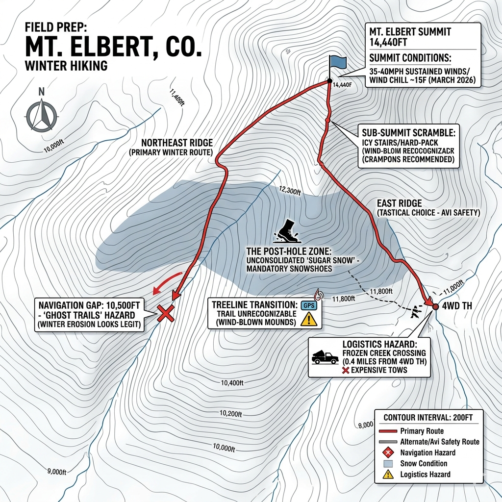

Field Report Summary (TL;DR): I have researched the last 10 condition reports for Mt. Elbert on 14ers.com as of March 20, 2026 @ 01:30 PM. The primary hazards currently involve a failing ice crossing 0.4 miles from the 4WD trailhead and a significant ‘trap door’ snow zone starting at 11,400′. Flotation is mandatory for success.
Field Prep: Mt. Elbert (Northeast/East Ridge) Technical Summary
Data based on reports from March 2026 and earlier winter/spring cycles.
1. Common Gear Failures & Logistics Hazards
- Traction Loss/Inadequacy: Several reports mention hikers losing crampons or failing to summit due to lack of flotation. Microspikes are currently mandatory; however, below 12,500′, high-density “trap door” snow has led to post-holing, rendering spikes ineffective without snowshoes.
- Access Barriers: The 4WD road to the upper trailhead is a primary failure point. Reports indicate a partially frozen creek crossing (0.4 miles from the 4WD TH) with “collapsed tire holes” and iced-over uphill sections. Attempting this without high clearance and lockers has resulted in expensive tows.
- Wind-Driven Gear Stress: Sustained winds of 35-40 mph with gusts up to 70 mph have been recorded. Hikers reported difficulty maintaining a standing position at the summit, highlighting the need for high-quality hardshells and wind-resistant eyewear.
2. Snow Line & Elevation Profiles
- General Trench: A well-established boot pack/trench exists from the parking lot to approximately 11,400′.
- The Post-hole Zone: The most difficult stretch for navigation and physical effort is between 11,400′ and 12,300′. This area currently contains unsupportive, knee-deep snow.
- The Sub-Summit Scramble: Above 13,100′ (near the rock wall), snow density decreases, with conditions shifting to 60/40 dirt and hard-packed snow. Spikes remain necessary for ice patches on the “stairs” about 2 miles in.
3. Specific Navigation & ‘Lost’ Points
- Treeline Transition (~11,800′): Multiple hikers report the trail becomes unrecognizable immediately after the treeline due to wind-blown mounds and “untracked” conditions. Hikers often naturally veer off-route here attempting to find solid ground.
- The Last 500 Feet: Visibility and trail markers become “unrecognizable” in the final 500 vertical feet to the summit, requiring GPS or strict adherence to the ridge spine.
- South Elbert Traverse: For those attempting the traverse, it is currently “untracked,” meaning navigation requires high-confidence route-finding as the visual trail is entirely obscured by snow or scree.
Field Recommendation
Start early (05:00) to utilize the frozen crust. If you are not in a high-clearance 4WD, park at the 2WD lot—the extra mileage is preferable to a river-bed recovery. Above 11k, do not trust the ‘perceived’ trail; keep your GPS active to avoid the common drift east of the ridge line.
Gear Lab: Field-Tested Recommendations
Based on the technical failure points identified in the latest reports, we recommend the following high-quality gear (Affiliate Links):
- MSR Lightning Ascent Snowshoes: The only way to beat the 11,400′ trap-door snow. 360-degree traction is essential for these technical slopes.
- Kahtoola MICROspikes: Essential for the sub-summit scramble above 13,100′.
- Garmin inReach Mini 2: Critical for navigation when the treeline transition disappears.
- Black Diamond Alpine Carbon Cork Poles: Necessary stability for 70mph summit gusts.
If you’re car camping or overlanding- check out my report on the best portable solar generators.